Trails Map
Bike Map
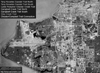
Aerial View
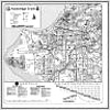
Description: Ship Creek Trail parallels Ship Creek from North C St Downtown 2.5 miles East-By-North to William Tyson Elementary School in Mountain View. The North C St Trailhead is located at the intersection of North C St and Ship Creek near the Alaska Railroad Corporate Building. The William Tyson Elementary School Trailhead is located at the West end of Richmond Ave. This tour starts at North C St and ends at Richmond Ave. The trail is marked by mileposts every 1/2 mile, beginning at North C St, increasing as you travel East-By-North. The trail is illuminated by lamps at night. The trail has a few minor grades; however, it is well suited to the novice user. Ship Creek flows West-By-South so traveling East-By-North is generally more strenuous.
Connections: To access the Coastal Trail from the North C St Trailhead, take North C St to 1st Ave to Christensen Dr to 2nd Ave. To access Glenn Highway Trail from the William Tyson Elementary School Trailhead, take Richmond Ave to Meyer St to Commercial Dr to Mountain View Dr. Mile 0 is adjacent to Davis Park.

(Tap or Click)
Highlights & Resources
-
Scenic Views of the Chugach Mountains & Downtown Anchorage
-
Moose, Small Mammals, Ducks, Geese, Birds & Fish
-
Numerous Bridges & Some Underpasses
-
Ship Creek/Alaska Railroad Bridge Complex
-
Sarah Bidwell Handicapped Fishing Platform & Knik Arm Power Plant Dam
-
Paved Trail, Minor Grades, Marked by Mileposts & Illuminated